The Regional Park of Colfiorito
From Jesse's Journeys in Italy
Map:
MapQuest
Whether driving south from
Camerino or north and east
from Foligno, one rises ever
upward along winding mountain
roads toward the small,
unprepossessing town of
Calfiorito on the border of
Umbria and the Marches.
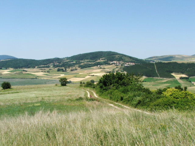
Coming round a bend in the road,
suddenly the landscape opens
into a wide, verdant and rolling
plateau, the Piani di
Colfiorito, a landscape
utterly different than anything
usually seen in Umbria, or in
the rest of Italy for that
matter.
A little to the west of the town
are the gates to the Regional
Park of Colfiorito, the
smallest protected area in
Umbria, consisting of a mere 50
square kilometers (338
hectares). The entire park
is between 750 and 800 km above
sea level.
Hikers, bicyclists, bird
watchers, fishers,
photographers, painters, and
anyone with an appetite for a
serene and beautiful landscape
will want to stop here and spend
at least a little time.
The best time of year to see the
park is in April and May when
the entire area is awash in
spring flowers, presenting a a
sublime visual and olfactory
experience that will implant
itself in the memory like few
others.
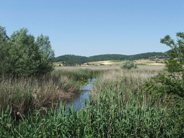
The area consists of seven
"bowls", the piani,
the most prepossessing of which is
a marsh known as the Palude
di Colfiorito, where one
finds flora and fauna rarely
seen elsewhere in Italy.
The marsh, which at its deepest
point is a mere 4 meters deep,
contains the common rush reed,
but also magnificent aquatic
orchids. Grey and purple
herons and wild geese will fly
up suddenly out of the reeds,
while mallards, bitterns and
shovelers skate along the
waters. Amphibious
creatures, toads, lizards, and
snakes skulk along the water's
edge. Stoats, fox and
hedgehogs find a home on dryer
ground.
The other six piani used to be
"wet", but have long since been
drained for agricultural
purposes, either for grain
production or the grazing of
cattle, sheep and goats.
These bowls are known as Cesi,
Popola, Annifo, Collecroce,
Arvello, and Ricciano.
If you have the legs for it,
walk the dirt road from the
marsh to the top of Mount Orve.
Not only will you enjoy a view
of almost the entire park and
the marsh below, but you will
come to the ruins of the
foundations of an ancient Roman
fort or lookout - encased for
the time being, in plaster.
Trails will lead you further
north and east to other roman ruins, and
ultimately to small villages and
settlements high in the hills of
the Marches.
The beauty of Parco
Colfiorito is striking and
memorable, but visitors should
also know the geography and
hydrology of the area is of
huge, practical importance
to all of Umbria. The
impermeable karst topography
carries some of the groundwater
into the piani, but most of it
finds its way into underground
cavities and fissures, then down
along the substrata where it
eventually feeds the springs
that are vital to the existence
of many other Umbrian towns
including Cassignano, Nocera
Umbra, Capodacqua, Rasiglia,
Bagnara, and Marsciano.
Our suggestion: pack a picnic
lunch, carry water, take your
time, and listen to the rustle
of the enveloping quiet.
For more information about the
Park:
Click here. |
|
Region of Umbria |
|
|
|
Directions |
|
From Rome (130K) go
east to Todi, then north
past Spoleto to
Foligno and then
take the SS77 toward
Camarino. From
Perugia, go east (35
km) to Foligno and
follow the S77. If
you are coming from
the north, say
Fabriano or Anacona
on the coast, take
Hwy 256 through
Camerino to the SS77
then head west
toward Calfiorto. |
|
Directory |
|

Diagram of the area |
|
Plestia
During the 2nd
Century, a Roman
town, Plestia
became an important
local economic and
political. Located
at the foot of Mount Pennino on the
Colfiorito plateau,
Plestia sat at the
crossroads of the
most important roads
in the central
Appenines. At
one time the town
was quite large
(over 60 hectares)
with its own archbishop.
Not much of it
remains, but there
are ruins of a Roman
town hall, basilica
and other buildings.
For more info |
| |
|